Mumbai, Bhārat’s financial capital and one of the most populous cities in the world, is a bustling metropolis with a fascinating history. Before it became the vibrant city we know today, Mumbai was an archipelago of seven islands, each with its own unique identity and story. These islands, over centuries, were gradually fused together through land reclamation to form the present-day Mumbai. Let’s delve into the history of these seven islands and explore how they transformed into a single urban expanse.

.svg)
Before the colonial era reshaped these shores, the islands were home to the Koli fishing communities, among the earliest inhabitants of the region. The Kolis had built their lives around the sea, navigating the creeks and inlets with a familiarity that no foreign power could replicate. Their presence long predates any recorded history of the islands, and their descendants still live in Mumbai today, in small coastal enclaves that feel almost anachronistic against the backdrop of skyscrapers and expressways. When the Portuguese arrived in the early 16th century, and later when the British took possession, they inherited a landscape already deeply inhabited and culturally layered.
Colaba

Located to the south of Bombay Island, Colaba was initially separated by a narrow creek. The island’s strategic position made it vital for defense during the colonial period, and the British used it as a garrison, stationing troops there to guard the southern approaches to the harbor. The name itself is thought to derive from the Koli word “Kolbhat,” a nod to the fishing communities who were its original inhabitants long before any fort or barracks appeared.
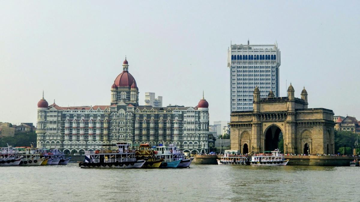
Colaba is now a bustling area known for its vibrant street markets, iconic landmarks like the Gateway of India, and the famous Taj Mahal Palace Hotel. The Gateway of India, built to commemorate King George V’s visit in 1911, has become the defining image of Mumbai’s waterfront, a triumphal arch that watched the last British troops sail away when India gained independence in 1948. That the same structure built to celebrate imperial power became the site of its symbolic departure is a particularly satisfying irony.
Old Woman’s Island (Little Colaba)
Old Woman’s Island, or Little Colaba, lies just north of Colaba. It got its name from the Koli fisherfolk community, who referred to it as “Al-Omani,” meaning “the old woman.” The island occupies a quiet corner of Mumbai’s origin story, less dramatic than its neighbors, without a defining fort or landmark to anchor it in popular memory. Historically, it was less developed compared to its neighbors, serving more as a buffer zone than a settlement in its own right.
Today, it is integrated into the larger Colaba area and is known for its upscale residential neighborhoods and consulate offices. The transformation is complete enough that most Mumbaikars would not know where Old Woman’s Island ends and Colaba begins, the distinction surviving only in historical maps and the memories of old Koli families.
Bombay Island (Isle of Bombay)
Bombay Island was the largest and the most significant of the seven islands, and in many ways, the seed from which the rest of the city grew. It housed the original settlement of Bombay, which derived its name from the Portuguese “Bombaim,” meaning “Good Bay,” a reflection of the natural harbor that made the island so attractive to seafaring traders.
The Portuguese controlled the island from the 1530s and built the foundations of what would become a major trading post. In 1661, Bombay Island was transferred to the English Crown as part of the dowry when King Charles II married the Portuguese princess Catherine of Braganza, one of the more unusual real estate transactions in history. The English East India Company leased it from the Crown for the nominal sum of ten pounds in gold per year, and from that moment, the island’s fate was sealed as a commercial hub of extraordinary ambition.
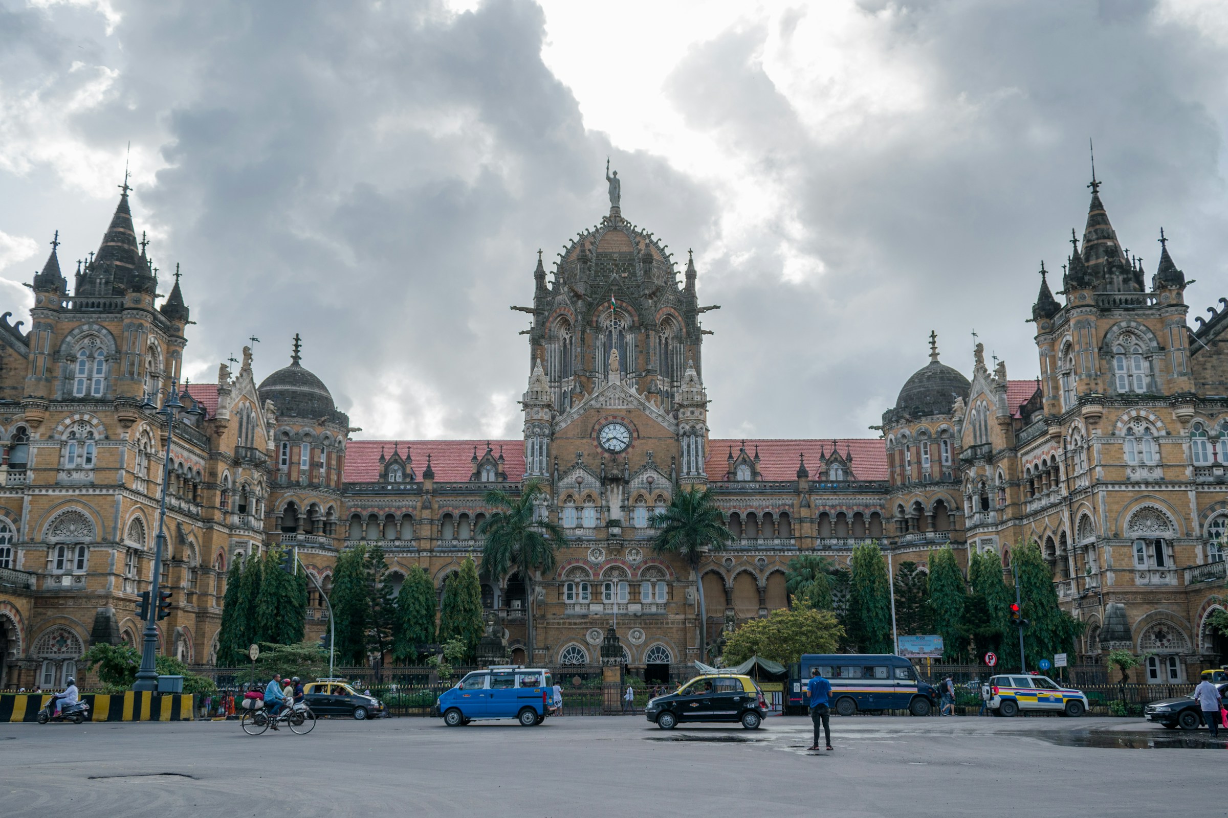
The natural harbor made it indispensable. Ships from Arabia, Persia, and East Africa had long used the western coast of Bhārat, and Bombay’s deep anchorage meant it could accommodate larger vessels than almost anywhere else along the Konkan coast. The Fort area in South Mumbai, with its colonial architecture, reflects this history, the Chhatrapati Shivaji Maharaj Terminus being among the most extravagant expressions of Victorian Gothic ambition anywhere in the world.
Mazagaon
Mazagaon was home to a diverse community of Portuguese and Indian residents, and its name is believed to derive from the Koli word for “fishermen’s village.” Under Portuguese rule it was known for its gardens, orchards, and coconut groves, a verdant contrast to the fortified settlements of neighboring islands. The Portuguese built churches and established a community that blended European and local traditions in ways that would shape the character of the island for generations.
Remnants of its colonial past can still be seen in structures like the Portuguese Church of Nossa Senhora de Bom Concelho. When the British eventually took control, Mazagaon’s dockyard became one of the most important ship-building facilities in the entire British Empire, constructing vessels that sailed to every corner of the globe. The dockyard still operates today, now under the Indian Navy, continuing a maritime tradition that is nearly five centuries old. Modern-day Mazagaon is a bustling residential and commercial district, reflecting the blend of old and new Mumbai.
Worli
Worli was known for its fishing villages long before the British arrived to build their fortifications. The Koli community here had one of the oldest and largest settlements on the archipelago, and the island’s rocky shoreline made it a natural lookout over the open sea. The Worli Fort, built by the British in the 17th century, was part of a network of coastal defenses designed to protect the growing trade settlement from Maratha and rival European threats.
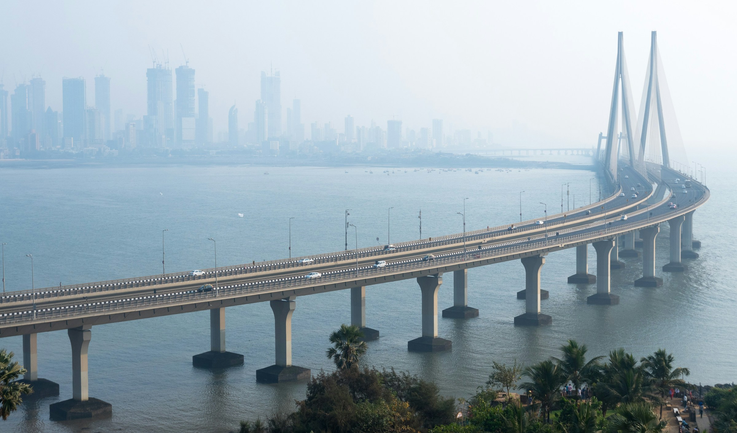
In modern times, Worli has undergone perhaps the most dramatic visual transformation of any of the seven islands. Where fishing boats once bobbed in quiet coves, the Bandra-Worli Sea Link now arcs across the water in a sweep of cable-stayed engineering, cutting commute times and announcing Mumbai’s ambitions for the 21st century. The contrast between the old Worli Fort crumbling quietly by the sea and the gleaming bridge rising behind it captures something essential about this city: the very old and the very new, coexisting without apology.
Parel
Parel Island was a serene area dominated by agricultural activities, dotted with temples, and home to a quieter, more pastoral way of life than its harbor-facing neighbors. The region was transformed during the British era when it became an industrial hub with numerous textile mills, earning it the name “Girangaon,” or “village of mills.” At the height of Bombay’s textile industry, Parel’s mills employed hundreds of thousands of workers who had migrated from across Maharashtra and beyond, giving the area a working-class identity and a radical political culture that made it the heart of the labor movement in colonial India.
The mills are mostly gone now, their vast brick structures converted into luxury residential complexes, corporate campuses, and art galleries. Parel today is a prime example of urban transformation, hosting some of Mumbai’s most expensive real estate alongside renowned healthcare institutions. The shift from mill workers’ chawls to five-star hotels happened within a single generation, making Parel a microcosm of the city’s relentless reinvention of itself.
Mahim
Mahim Island was once a key stronghold during various colonial and indigenous reigns, its position at the northern end of the archipelago making it a crucial point of control. The Mahim Fort, built by the Portuguese in the 16th century, still stands as a reminder of the island’s strategic importance, guarding what was once the main entrance to the islands from the north.
Mahim’s history is also a story of religious complexity. The Mahim Dargah, dedicated to the Sufi saint Makhdoom Ali Mahimi, has been a site of veneration for Muslims, Hindus, and Christians alike for centuries, a tradition of shared devotion that speaks to the syncretic spirit that has long defined Mumbai’s social fabric. Mahim is now a densely populated area known for its historical churches, bustling markets, and the Mahim Causeway, which connects it to other parts of Mumbai and was one of the first major pieces of infrastructure to begin knitting the separate islands together.
Stitching the Islands Together
The transformation from seven islands to a unified Mumbai was not a single event but a gradual, centuries-long process. The earliest connections were informal: sandbars and shallow creeks that could be crossed at low tide. The Portuguese began small-scale reclamation work, but it was the British who undertook the project systematically. The Hornby Vellard, completed in 1784, was the decisive intervention, a massive embankment that closed off the Worli creek and prevented the daily flooding that had long made large parts of the archipelago uninhabitable. Named after Governor William Hornby, who pushed the project through despite opposition from the East India Company in London, the Vellard effectively merged the northern islands and opened vast new areas of land for settlement.
Further reclamation followed through the 19th and 20th centuries, driven by the city’s insatiable appetite for space. Land that had been open sea became neighborhoods, the sea itself retreating before the ambitions of the growing metropolis. Today Mumbai covers an area of roughly 600 square kilometers, much of it land that did not exist two centuries ago.
Today, the legacy of the seven islands is embedded in the fabric of Mumbai, with each area reflecting its unique history while contributing to the dynamic and cosmopolitan character of the city. From historic forts and colonial architecture to bustling markets and modern skyscrapers, Mumbai’s evolution from an archipelago to a metropolis is a testament to its resilience and adaptability. What makes the story of these seven islands so compelling is not just the scale of the transformation, but the human continuity running through it: the Koli fishermen who were here first, still casting their nets in the shadow of glass towers, connecting the city of today to an archipelago that, in living memory, was still mostly sea.